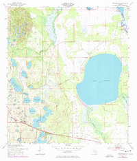
1952 Map of Hesperides
USGS Topo · Published 1972About this map
The settlement of Hesperides and the surrounding lake country of Polk County are defined by a complex hydrology of marshes and interconnecting waterways. This 1952 survey shows the Seaboard Coast Line railroad threading through the southern landscape, connecting the citrus-growing region of Alcoma to the wider world. The interior is a mosaic of water bodies, from the large expanse of Lake Rosalie to smaller pools like Saddlebag Lake and Lake Aurora. Along the banks of the Kissimmee River and Lake Hatchineha, developments such as Camp Mack indicate the early 20th-century character of these Florida shorelines. Local landmarks like the St Anne Shrine and Beulah Ch reflect the community life established amidst the wet prairies and islands like Buster Island. The map provides a clear look at the drainage patterns of Catfish Creek and Rosalie Creek before more modern modifications to the regional watershed occurred.
Find a feature on this map
27 named features on this map. Tap any name to fly to it.
Don’t see what you’re looking for? This feature index may not catch every label — zoom into the map to look around manually.
Map Details
Editions of this 1952 Hesperides Map
4 editions found
Other maps of this area

1952 · Lake Wales
USGS Topo · 1:24,000

1952 · Lake Weohyakapka SE
USGS Topo · 1:24,000

1952 · Lake Weohyakapka NE
USGS Topo · 1:24,000

1952 · Babson Park
USGS Topo · 1:24,000

1952 · Hesperides
USGS Topo · 1:24,000

1952 · Lake Weohyakapka
USGS Topo · 1:24,000

1953 · Cypress Lake
USGS Topo · 1:24,000

1953 · Dundee
USGS Topo · 1:24,000

1953 · Lake Hatchineha
USGS Topo · 1:24,000

1955 · Orlando
USGS Topo · 1:250,000