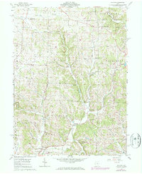
1961 Map of Hickman
USGS Topo · Published 1971About this map
The Jackson Oil and Gas Field dominates the northern reaches of this Licking County landscape, where numerous Gas Wells and Oil Wells are interspersed among the ridges of Clay and Fallsbury townships. The map documents a rural Ohio network of small crossroads communities and country institutions, including the settlement of Hickman and the nearby Burrell Chapel. Moving south through Maryann, the terrain is defined by the steep valleys carved by the Rocky Fork and its tributaries like Wilkins Run and Lost Run.
Find a feature on this map
37 named features on this map. Tap any name to fly to it.
Don’t see what you’re looking for? This feature index may not catch every label — zoom into the map to look around manually.
Map Details
Editions of this 1961 Hickman Map
4 editions found
Other maps of this area

1909 · Newark
USGS Topo · 1:62,500

1910 · Frazeysburg
USGS Topo · 1:62,500

1912 · Gambier
USGS Topo · 1:62,500

1913 · Brinkhaven
USGS Topo · 1:62,500

1914 · Gambier
USGS Topo · 1:62,500

1915 · Brinkhaven
USGS Topo · 1:62,500

1943 · Gambier
USGS Topo · 1:62,500

1950 · Marion
USGS Topo · 1:250,000

1961 · Hanover
USGS Topo · 1:24,000

1961 · Newark
USGS Topo · 1:24,000