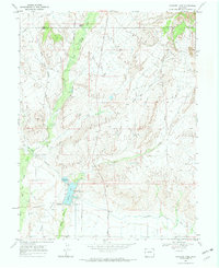
1968 Map of Highline Lake
USGS Topo · Published 1972About this map
Highline Lake State Recreational Area serves as a focal point for water management and public use on the high desert plains near the Garfield and Mesa County line. Surveyed in the late 1960s, this landscape illustrates the critical role of irrigation infrastructure in Western development, anchored by the extensive Government Highline Canal and the functional engineering of the Siphon and Spillway. While the southern portion of the map shows a network of planned routes like Twelve Thirteen Road and a local Landing Strip, the northern reaches remain defined by rugged drainage systems including Demaree Canyon and Salt Creek. The presence of both Highline Lake and Mack Mesa Lake underscores the transition from the natural arid washes of Coyote Wash and East Mack Wash to a managed hydraulic environment designed for recreation and agriculture.
Find a feature on this map
23 named features on this map. Tap any name to fly to it.
Don’t see what you’re looking for? This feature index may not catch every label — zoom into the map to look around manually.
Map Details
Editions of this 1968 Highline Lake Map
2 editions found
Other maps of this area

1956 · Grand Junction
USGS Topo · 1:250,000

1959 · Grand Junction
USGS Topo · 1:250,000

1960 · Grand Junction
USGS Topo · 1:250,000

1962 · Grand Junction
USGS Topo · 1:250,000

1962 · Fruita
USGS Topo · 1:24,000

1962 · Mack
USGS Topo · 1:24,000

1964 · Grand Junction
USGS Topo · 1:250,000

1965 · Grand Junction
USGS Topo · 1:250,000

1968 · Badger Wash
USGS Topo · 1:24,000
1968 · Carbonera
USGS Topo · 1:24,000