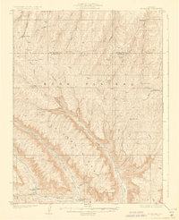
1929 Map of Highmore
USGS Topo · Published 1929About this map
Book Plateau and the deeply incised drainage of Clear Creek dominate this 1920s survey of the Garfield and Rio Blanco county line. The landscape is defined by its isolation, dotted with family-named outposts and seasonal shelters such as Brookners Cabin, Denton Cabin, and Scouts Cabin. The presence of the Good Hope Shale Camp in the western reaches suggests the early industrial interest in the region's oil shale reserves, while the remote Highmore PO and nearby Carr Creek School served as the primary social anchors for the scattered ranching and mining population.
Find a feature on this map
62 named features on this map. Tap any name to fly to it.
Don’t see what you’re looking for? This feature index may not catch every label — zoom into the map to look around manually.
Map Details
Editions of this 1929 Highmore Map
3 editions found
Other maps of this area

1925 · Parachute Creek
USGS Topo · 1:62,500

1927 · Parachute Creek
USGS Topo · 1:62,500

1929 · Grand Valley
USGS Topo · 1:62,500

1929 · Highmore
USGS Topo · 1:62,500

1929 · Roan Creek
USGS Topo · 1:62,500

1952 · Yankee Gulch
USGS Topo · 1:24,000

1952 · Rock School
USGS Topo · 1:24,000

1952 · Jessup Gulch
USGS Topo · 1:24,000

1956 · Grand Junction
USGS Topo · 1:250,000

1959 · Grand Junction
USGS Topo · 1:250,000