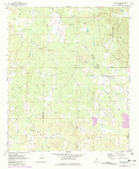
1972 Map of Highpoint
USGS Topo · Published 1982About this map
Highpoint sits along the dividing line of the Choctaw Co Winston Co border, serving as a focal point for the surrounding rural communities during the early 1970s. The area is characterized by a dense network of country churches and family-named cemeteries, such as Big Jerusalem Ch and the Old Concord Cem, which indicate long-standing settlement patterns in this part of Mississippi. The Illinois Central Gulf railroad cuts through the center of the sheet, providing a vital transport corridor through the varied landscape of the Tombigbee National Forest. To the south and west, numerous watercourses including Tallahaga Creek and Lobutcha Creek drain the timbered terrain, reflecting the geographical importance of the local watershed to the region's agricultural and forest-based economy.
Find a feature on this map
28 named features on this map. Tap any name to fly to it.
Don’t see what you’re looking for? This feature index may not catch every label — zoom into the map to look around manually.
Map Details
Editions of this 1972 Highpoint Map
2 editions found
Other maps of this area

1953 · West Point
USGS Topo · 1:250,000

1958 · West Point
USGS Topo · 1:250,000

1963 · West Point
USGS Topo · 1:250,000

1966 · Weir
USGS Topo · 1:24,000

1968 · Weir
USGS Topo · 1:62,500

1972 · Louisville North
USGS Topo · 1:24,000

1972 · McCool
USGS Topo · 1:24,000

1972 · Highpoint
USGS Topo · 1:24,000
1972 · Ethel SE
USGS Topo · 1:24,000
1972 · Louisville South
USGS Topo · 1:24,000