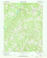
1968 Map of Hillcrest
USGS Topo · Published 1971About this map
Cumberland State Forest dominates the northern landscape of this Virginia Piedmont quadrangle, where the Willis River winds through the western boundary. The settlement pattern reveals a rural network of named crossroads and small communities, such as Hillcrest, McRae, and Cotton Town, many of which grew around local hubs like Browns Store and Guinea Mills. This late-1960s survey provides a detailed record of local genealogy and infrastructure, documenting numerous houses of worship including Grace Ch, Tear Wallet Ch, and Guinea Ch. Education and social services are anchored by Jackson High Sch, while the drainage of the area is defined by the winding paths of Big Guinea Creek and Horsepen Creek. The map effectively captures the transition of the region as traditional farming hubs like Angola maintained their identity within the forest-draped terrain.
Find a feature on this map
39 named features on this map. Tap any name to fly to it.
Don’t see what you’re looking for? This feature index may not catch every label — zoom into the map to look around manually.
Map Details
Editions of this 1968 Hillcrest Map
4 editions found
Other maps of this area

1891 · Palmyra
USGS Topo · 1:125,000

1891 · Farmville
USGS Topo · 1:125,000

1893 · Farmville
USGS Topo · 1:125,000

1895 · Palmyra
USGS Topo · 1:125,000

1897 · Palmyra
USGS Topo · 1:125,000

1947 · Roanoke
USGS Topo · 1:250,000

1950 · Dillwyn
USGS Topo · 1:62,500

1958 · Farmville
USGS Topo · 1:62,500

1958 · Jetersville
USGS Topo · 1:62,500

1958 · Dillwyn
USGS Topo · 1:62,500