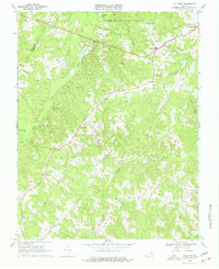
1968 Map of Hillcrest
USGS Topo · Published 1977About this map
The Cumberland State Forest dominates the northern reaches of this Virginia landscape, where the Willis River meanders through dense woodlands and past the historic Ca Ira Pond. This late 1960s survey documents a rural network of small communities and family-named landmarks such as Guinea Mills, Browns Store, and Cotton Town. The distribution of community centers like Jackson High Sch and numerous country churches, including Grace Ch, Antioch Ch, and Guinea Ch, illustrates the social geography of the era. To the east, the county seat of Cumberland and the settlement of Hillcrest are connected by a winding road system, while the southern boundary follows the path of Angola Creek and the Buckingham and Cumberland county line. Local history is preserved in the names of various water bodies like Bear Creek and Dear Wallet Creek, providing a detailed look at the Piedmont's rural landscape.
Find a feature on this map
45 named features on this map. Tap any name to fly to it.
Don’t see what you’re looking for? This feature index may not catch every label — zoom into the map to look around manually.
Map Details
Editions of this 1968 Hillcrest Map
4 editions found
Other maps of this area

1891 · Palmyra
USGS Topo · 1:125,000

1891 · Farmville
USGS Topo · 1:125,000

1893 · Farmville
USGS Topo · 1:125,000

1895 · Palmyra
USGS Topo · 1:125,000

1897 · Palmyra
USGS Topo · 1:125,000

1947 · Roanoke
USGS Topo · 1:250,000

1950 · Dillwyn
USGS Topo · 1:62,500

1958 · Farmville
USGS Topo · 1:62,500

1958 · Jetersville
USGS Topo · 1:62,500

1958 · Dillwyn
USGS Topo · 1:62,500