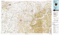
1986 Map of Hillsboro
USGS Topo · Published 1990About this map
Hillsboro and Wilmington anchor this mid-1980s landscape, where the flat agricultural plains of western Ohio meet the rising hills of the Allegheny Plateau. The map reveals a transition from the rectangular township grids of Clinton Co and Highland Co to the more varied, wooded topography of the Shawnee State Forest and Pike State Forest in the southeast. Transportation is a central theme, with the Baltimore and Ohio Railroad and Norfolk and Western Railway cutting across the terrain, connecting industrial centers like Chillicothe and Greenfield.
Find a feature on this map
255 named features on this map. Tap any name to fly to it.
Don’t see what you’re looking for? This feature index may not catch every label — zoom into the map to look around manually.
Map Details
Editions of this 1986 Hillsboro Map
2 editions found
Other maps of this area

1906 · Waverly
USGS Topo · 1:62,500

1906 · Mt Sterling
USGS Topo · 1:62,500

1906 · Chillicothe
USGS Topo · 1:62,500

1907 · Blanchester
USGS Topo · 1:62,500

1908 · Chillicothe
USGS Topo · 1:62,500

1908 · Waverly
USGS Topo · 1:62,500

1911 · Era
USGS Topo · 1:62,500

1911 · Sciotoville
USGS Topo · 1:62,500

1912 · Roxabell
USGS Topo · 1:62,500

1913 · Waynesville
USGS Topo · 1:62,500