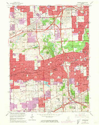
1963 Map of Hinsdale
USGS Topo · Published 1973About this map
Mt Carmel Cemetery and Queen of Heaven Cemetery anchor the northeastern landscape of this suburban expanse, reflecting the area's significance as a spiritual and commemorative hub west of Chicago. The survey captures a moment of intense postwar development as communities like Hinsdale, Westmont, and Downers Grove expand alongside major infrastructure. A distinctive Treaty Boundary line cuts across the terrain, a cartographic ghost of earlier land divisions that persists amidst the burgeoning grid of residential streets and sprawling institutions like St Josephs Seminary and Bethany Seminary.
Find a feature on this map
151 named features on this map. Tap any name to fly to it.
Don’t see what you’re looking for? This feature index may not catch every label — zoom into the map to look around manually.
Map Details
Editions of this 1963 Hinsdale Map
3 editions found
Other maps of this area

1890 · Des Plaines
USGS Topo · 1:62,500

1891 · Riverside
USGS Topo · 1:62,500

1892 · Joliet
USGS Topo · 1:62,500

1893 · Riverside
USGS Topo · 1:62,500

1894 · Des Plaines
USGS Topo · 1:62,500

1900 · Des Plaines
USGS Topo · 1:62,500

1900 · Riverside
USGS Topo · 1:62,500

1901 · Des Plaines
USGS Topo · 1:62,500

1901 · Riverside
USGS Topo · 1:62,500

1908 · Wheaton
USGS Topo · 1:62,500