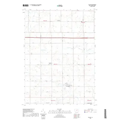
2018 Map of Holland
USGS Topo · Published 2018About this map
Holland and the northern outskirts of Grundy Center anchor this agricultural landscape in Grundy County, where a grid of rural roads and section lines defines the local geography. The map reveals a community deeply rooted in its local institutions, evidenced by sites like the Colfax Center Presbyterian Church Cem and the Pleasant Valley Reformed Cem. These landmarks, along with the small settlement of Fern near the northern boundary, point to a history of organized township settlement and local congregation centers. The terrain is drained by several branches of the Black Hawk and Beaver creek systems, including the S Fork Blackhawk Cr and the meandering Holland Cr. The convergence of naming conventions, such as Hoxie and Marble Rd, alongside the standard numbered street system, provides a detailed record of the road network at the end of the second decade of the 21st century.
Find a feature on this map
45 named features on this map. Tap any name to fly to it.
Don’t see what you’re looking for? This feature index may not catch every label — zoom into the map to look around manually.
Map Details
Editions of this 2018 Holland Map
This is the sole edition of this map. No revisions or reprints were ever made.
Other maps of this area

1954 · Waterloo
USGS Topo · 1:250,000

1955 · Waterloo
USGS Topo · 1:250,000

1971 · Dike
USGS Topo · 1:24,000

1971 · Lincoln
USGS Topo · 1:24,000

1971 · Stout
USGS Topo · 1:24,000

1979 · Grundy Center
USGS Topo · 1:24,000

1979 · Holland
USGS Topo · 1:24,000

1980 · Aplington
USGS Topo · 1:24,000

1980 · Wellsburg
USGS Topo · 1:24,000
1980 · Ivester
USGS Topo · 1:24,000