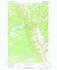
1965 Map of Holland Lake
USGS Topo · Published 1978About this map
Holland Lake serves as a central landmark in this mid-1960s survey of the high country where the Bob Marshall Wilderness meets the Flathead National Forest. The landscape is defined by its network of high-elevation water bodies and drainage systems, from the Necklace Lakes in the north to the headwaters of the Clearwater River and Clearwater Lake in the south. The mapping of the Holland Gordon Trail and the Foothills Trail indicates the established routes used by packers and foresters through Gordon Pass.
Find a feature on this map
38 named features on this map. Tap any name to fly to it.
Don’t see what you’re looking for? This feature index may not catch every label — zoom into the map to look around manually.
Map Details
Editions of this 1965 Holland Lake Map
2 editions found

Other maps of this area

1902 · Ovando
USGS Topo · 1:125,000

1905 · Ovando
USGS Topo · 1:125,000

1921 · Elbow Lake
USGS Topo · 1:125,000

1936 · Silvertip
USGS Topo · 1:96,000

1942 · Silvertip
USGS Topo · 1:125,000

1955 · Choteau
USGS Topo · 1:250,000

1957 · Choteau
USGS Topo · 1:250,000

1958 · Choteau
USGS Topo · 1:250,000

1962 · Choteau
USGS Topo · 1:250,000

1965 · Condon
USGS Topo · 1:24,000