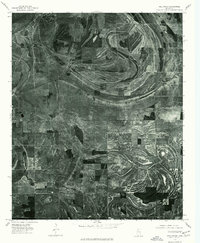
1975 Map of Hollywood
USGS Topo · Published 1976About this map
The alluvial plains of the Mississippi Delta are captured in high-resolution detail through this 1975 orthophotoquad. Centered on the settlement of Hollywood and the eastern outskirts of Tunica, the imagery reveals an intricate landscape of agricultural field patterns and oxbow remnants. Unlike a traditional line-and-symbol map, this aerial survey provides a direct view of the land's texture, showing the meandering path of Jack Lake Bayou and the winding course of Whiteoak Bayou as they cut through the heavy-cropping country. The distinct contrast between the dark woodlots and the light, geometric fields illustrates the highly developed drainage and cultivation systems of the mid-1970s Delta. Researchers can observe the specific placement of farmsteads and rural road networks that define this region's agricultural economy during the late twentieth century.
Find a feature on this map
4 named features on this map. Tap any name to fly to it.
Don’t see what you’re looking for? This feature index may not catch every label — zoom into the map to look around manually.
Map Details
Editions of this 1975 Hollywood Map
This is the sole edition of this map. No revisions or reprints were ever made.
Other maps of this area

1908 · Dundee
USGS Topo · 1:24,000

1908 · Hollywood
USGS Topo · 1:24,000

1908 · Walnut Lake
USGS Topo · 1:24,000

1910 · Dundee
USGS Topo · 1:31,680

1910 · Walnut Lake
USGS Topo · 1:31,680

1913 · Hollywood
USGS Topo · 1:31,680

1931 · Horseshoe Lake
USGS Topo · 1:62,500

1932 · Horn Lake
USGS Topo · 1:48,000

1932 · Crenshaw
USGS Topo · 1:62,500

1935 · Crenshaw
USGS Topo · 1:62,500