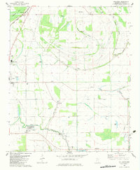
1982 Map of Hollywood
USGS Topo · Published 1983About this map
Hollywood and Tunica North anchor this agricultural landscape in the early 1980s, where the Illinois Central Gulf railroad cuts a straight line through the alluvial plains. The terrain is defined by a dense network of meandering waterways, including Buck Island Bayou and Minton Bayou, which reflect the historic drainage patterns of the Delta. This period shows a transition in land use, marked by the presence of a Fish Farm near Little Texas and several municipal developments like a Sewage Disposal Pond near White Oak Bayou.
Find a feature on this map
48 named features on this map. Tap any name to fly to it.
Don’t see what you’re looking for? This feature index may not catch every label — zoom into the map to look around manually.
Map Details
Editions of this 1982 Hollywood Map
This is the sole edition of this map. No revisions or reprints were ever made.
Other maps of this area

1908 · Dundee
USGS Topo · 1:24,000

1908 · Hollywood
USGS Topo · 1:24,000

1908 · Walnut Lake
USGS Topo · 1:24,000

1910 · Dundee
USGS Topo · 1:31,680

1910 · Walnut Lake
USGS Topo · 1:31,680

1913 · Hollywood
USGS Topo · 1:31,680

1931 · Horseshoe Lake
USGS Topo · 1:62,500

1932 · Horn Lake
USGS Topo · 1:48,000

1932 · Crenshaw
USGS Topo · 1:62,500

1935 · Crenshaw
USGS Topo · 1:62,500