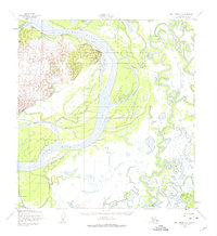
1952 Map of Holy Cross A-2
USGS Topo · Published 1975About this map
Holy Cross stands as a primary settlement along the western bank of the Yukon River in this 1952 survey, which captures the complex aquatic landscape of interior Alaska. The confluence of the Innoko River and the Yukon creates a dense network of braided channels and shifting landmasses, including Salmon Island and Horse Island. The mapping of several sloughs, such as Walker Slough, Red Wing Slough, and Fat John Slough, illustrates the dynamic nature of this riverine environment where water routes were essential for regional movement.
Find a feature on this map
22 named features on this map. Tap any name to fly to it.
Don’t see what you’re looking for? This feature index may not catch every label — zoom into the map to look around manually.
Map Details
Editions of this 1952 Holy Cross A-2 Map
3 editions found
Other maps of this area

1947 · Russian Mission
USGS Topo · 1:250,000

1950 · Russian Mission
USGS Topo · 1:250,000

1951 · Holy Cross
USGS Topo · 1:250,000

1952 · Holy Cross B-2
USGS Topo · 1:63,360

1952 · Holy Cross A-2
USGS Topo · 1:63,360

1952 · Holy Cross A-1
USGS Topo · 1:63,360

1952 · Holy Cross B-3
USGS Topo · 1:63,360

1952 · Holy Cross B-1
USGS Topo · 1:63,360

1952 · Holy Cross A-3
USGS Topo · 1:63,360

1952 · Russian Mission D-2
USGS Topo · 1:63,360