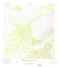
1952 Map of Holy Cross A-3
USGS Topo · Published 1975About this map
The Yukon River carves a massive path through the southeastern corner of this 1952 landscape, defining a region of intricate waterways and shifting embankments. Rising above the riverbanks, the Paimut and Holy Cross Hills dominate the topography, providing a stark vertical contrast to the low-lying sloughs that branch from the main channel. This survey, compiled from aerial photography, illustrates a wilderness tied to seasonal movement, featuring the Winter Trail as a primary terrestrial route.
Find a feature on this map
12 named features on this map. Tap any name to fly to it.
Don’t see what you’re looking for? This feature index may not catch every label — zoom into the map to look around manually.
Map Details
Editions of this 1952 Holy Cross A-3 Map
3 editions found
Other maps of this area

1947 · Russian Mission
USGS Topo · 1:250,000

1950 · Russian Mission
USGS Topo · 1:250,000

1951 · Holy Cross
USGS Topo · 1:250,000

1952 · Holy Cross B-2
USGS Topo · 1:63,360

1952 · Holy Cross A-2
USGS Topo · 1:63,360

1952 · Holy Cross A-4
USGS Topo · 1:63,360

1952 · Holy Cross B-3
USGS Topo · 1:63,360

1952 · Holy Cross A-3
USGS Topo · 1:63,360

1952 · Holy Cross B-4
USGS Topo · 1:63,360

1952 · Holy Cross
USGS Topo · 1:250,000