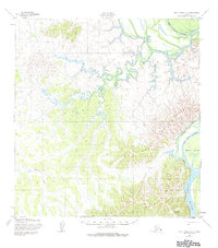
1952 Map of Holy Cross A-3
USGS Topo · Published 1984About this map
The Yukon River carves a massive course through this subarctic interior landscape, where complex hydrologic systems like Deer Hunting Slough and Big Bend Slough reflect the shifting nature of the river's path. In the southeast, the land rises sharply toward Tabernacle Mountain and the Paimut Hills, providing a stark contrast to the low-lying wetlands and the wandering Koserefski River in the north. The area's mid-century character is defined by its seasonal reliance on these waterways and a single overland Trail. A notable landform, Horse Island, sits prominently in the main channel near the mouth of Crooked Lake, serving as a landmark for navigation along this remote stretch of the Yukon. The topographic details captured here depict a wilderness where geography is dictated by the spring breakup and the drainage of Mountain Creek from the Holy Cross Hills.
Find a feature on this map
11 named features on this map. Tap any name to fly to it.
Don’t see what you’re looking for? This feature index may not catch every label — zoom into the map to look around manually.
Map Details
Editions of this 1952 Holy Cross A-3 Map
3 editions found
Other maps of this area

1947 · Russian Mission
USGS Topo · 1:250,000

1950 · Russian Mission
USGS Topo · 1:250,000

1951 · Holy Cross
USGS Topo · 1:250,000

1952 · Holy Cross B-2
USGS Topo · 1:63,360

1952 · Holy Cross A-2
USGS Topo · 1:63,360

1952 · Holy Cross A-4
USGS Topo · 1:63,360

1952 · Holy Cross B-3
USGS Topo · 1:63,360

1952 · Holy Cross A-3
USGS Topo · 1:63,360

1952 · Holy Cross B-4
USGS Topo · 1:63,360

1952 · Holy Cross
USGS Topo · 1:250,000