
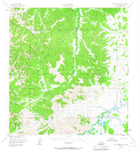
1952 Map of Holy Cross A-4
USGS Topo · Published 1974About this map
The Kilbuck Mountains dominate this 1952 landscape in the Yukon-Koyukuk region, where the Stuyahok River carves a winding path through the western foothills. At the river’s edge, the small settlement of Stuyahok represents a critical interior outpost, supported by a nearby Landing Strip and a primitive Cabin. This survey, mapped by the Army Map Service, captures the reliance on seasonal transport in the Alaskan interior, specifically highlighting a Winter Trail that cuts across the northern terrain. To the southeast, the landscape transitions to a complex aquatic network where Mountain Creek meets the meandering waters of Tuckers Slough, indicating a low-lying drainage pattern typical of the river valleys before they reach the larger Yukon system. The map provides a precise record of these isolated landmarks and navigation routes during the early 1950s.
Find a feature on this map
9 named features on this map. Tap any name to fly to it.
Don’t see what you’re looking for? This feature index may not catch every label — zoom into the map to look around manually.
Map Details
Editions of this 1952 Holy Cross A-4 Map
3 editions found
Other maps of this area

1947 · Russian Mission
USGS Topo · 1:250,000

1950 · Russian Mission
USGS Topo · 1:250,000

1951 · Holy Cross
USGS Topo · 1:250,000

1951 · Holy Cross A-5
USGS Topo · 1:63,360

1952 · Holy Cross A-4
USGS Topo · 1:63,360

1952 · Holy Cross B-3
USGS Topo · 1:63,360

1952 · Holy Cross B-5
USGS Topo · 1:63,360

1952 · Holy Cross A-3
USGS Topo · 1:63,360

1952 · Holy Cross B-4
USGS Topo · 1:63,360

1952 · Holy Cross
USGS Topo · 1:250,000