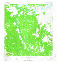
1952 Map of Holy Cross B-4
USGS Topo · Published 1963About this map
The Bonasila River meanders through a complex network of wetlands and oxbow lakes in this interior Alaskan landscape. Mapping conducted by the Army Map Service in the early 1950s captures the transition from riverine lowlands to more prominent elevations such as Two Spot Mountain and Bonasila Dome. The drainage pattern is defined by the winding course of the Stuyahok River and Stanstrom Creek, which cut through terrain that was largely unsurveyed and unmarked at the time of the field annotation. This survey reflects the region's wilderness state prior to modern development, focusing on the natural geography and water systems that dictated travel and survival in the Yukon-Koyukuk area.
Find a feature on this map
5 named features on this map. Tap any name to fly to it.
Don’t see what you’re looking for? This feature index may not catch every label — zoom into the map to look around manually.
Map Details
Editions of this 1952 Holy Cross B-4 Map
3 editions found
Other maps of this area

1951 · Holy Cross
USGS Topo · 1:250,000

1951 · Holy Cross A-5
USGS Topo · 1:63,360

1952 · Holy Cross A-4
USGS Topo · 1:63,360

1952 · Holy Cross C-5
USGS Topo · 1:63,360

1952 · Holy Cross B-3
USGS Topo · 1:63,360

1952 · Holy Cross B-5
USGS Topo · 1:63,360

1952 · Holy Cross C-3
USGS Topo · 1:63,360

1952 · Holy Cross A-3
USGS Topo · 1:63,360

1952 · Holy Cross C-4
USGS Topo · 1:63,360

1952 · Holy Cross B-4
USGS Topo · 1:63,360