
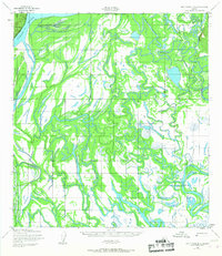
1952 Map of Holy Cross D-2
USGS Topo · Published 1959About this map
The Holikachuk settlement sits at the heart of this intricate riverine landscape, where the Innoko River meanders toward its convergence with the Shageluk Slough. This 1950s-era survey by the Army Map Service reveals a complex network of wetlands and waterways, characterized by the broad course of the Yukon River and the significant landform of Eagle Island. A Winter Trail provides a trace of seasonal overland movement through the terrain, illustrating the importance of specific corridors for travel across the low-lying interior before modern infrastructure arrived. The mapping captures a highly fluid environment of shifting sloughs and river channels that defined the livelihoods and transportation routes of the region's inhabitants.
Find a feature on this map
9 named features on this map. Tap any name to fly to it.
Don’t see what you’re looking for? This feature index may not catch every label — zoom into the map to look around manually.
Map Details
Editions of this 1952 Holy Cross D-2 Map
2 editions found
Other maps of this area

1951 · Unalakleet
USGS Topo · 1:250,000

1951 · Holy Cross
USGS Topo · 1:250,000

1952 · Unalakleet A-2
USGS Topo · 1:63,360

1952 · Unalakleet A-3
USGS Topo · 1:63,360

1952 · Unalakleet A-1
USGS Topo · 1:63,360

1952 · Holy Cross C-2
USGS Topo · 1:63,360

1952 · Holy Cross C-1
USGS Topo · 1:63,360

1952 · Holy Cross D-3
USGS Topo · 1:63,360

1952 · Holy Cross D-1
USGS Topo · 1:63,360

1952 · Holy Cross C-3
USGS Topo · 1:63,360