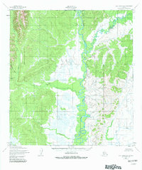
1952 Map of Holy Cross D-4
USGS Topo · Published 1982About this map
The Anyik River and Yellow River dominate this interior landscape, winding through a complex system of low-lying wetlands and upland ridges. Surveyed in the early 1950s, the map reveals a remote territory where travel followed the water, evidenced by the small clusters of Cabins and a lone Cabin situated at strategic points along the riverbanks. This area, north of the North Boundary Seward Meridian, shows a drainage pattern where numerous tributaries like Beaver Creek, Theodore Creek, and Goblet Creek feed into the larger river systems.
Find a feature on this map
10 named features on this map. Tap any name to fly to it.
Don’t see what you’re looking for? This feature index may not catch every label — zoom into the map to look around manually.
Map Details
Editions of this 1952 Holy Cross D-4 Map
3 editions found
Other maps of this area

1951 · Unalakleet
USGS Topo · 1:250,000

1951 · Holy Cross
USGS Topo · 1:250,000

1952 · Unalakleet A-4
USGS Topo · 1:63,360

1952 · Unalakleet A-3
USGS Topo · 1:63,360

1952 · Unalakleet A-5
USGS Topo · 1:63,360

1952 · Holy Cross C-5
USGS Topo · 1:63,360

1952 · Holy Cross D-5
USGS Topo · 1:63,360

1952 · Holy Cross D-4
USGS Topo · 1:63,360

1952 · Holy Cross D-3
USGS Topo · 1:63,360

1952 · Holy Cross C-3
USGS Topo · 1:63,360