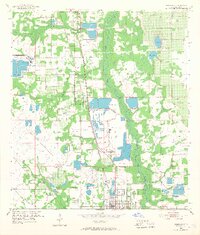
1952 Map of Homeland
USGS Topo · Published 1968About this map
Fort Meade and Homeland serve as the primary population centers in this mid-century Florida landscape, which is heavily defined by the phosphate mining industry. The map reveals an extensive network of extractive operations, including the Noralyn Mine and numerous Strip Mines, which have fundamentally reshaped the terrain between Sixmile Branch and the Peace River. Large settling ponds and mine dumps are interspersed with natural features like Sand Lake and Mud Lake, illustrating the proximity of industrial activity to the region's traditional hydrology.
Find a feature on this map
31 named features on this map. Tap any name to fly to it.
Don’t see what you’re looking for? This feature index may not catch every label — zoom into the map to look around manually.
Map Details
Editions of this 1952 Homeland Map
5 editions found
Other maps of this area

1949 · Mulberry
USGS Topo · 1:24,000

1949 · Bartow
USGS Topo · 1:24,000

1949 · Bradley Junction
USGS Topo · 1:24,000

1950 · Mulberry
USGS Topo · 1:24,000

1950 · Bartow
USGS Topo · 1:24,000

1950 · Bradley Junction
USGS Topo · 1:24,000

1952 · Homeland
USGS Topo · 1:24,000

1955 · Eloise
USGS Topo · 1:24,000

1955 · Bowling Green
USGS Topo · 1:24,000

1955 · Baird
USGS Topo · 1:24,000