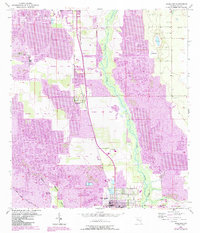
1952 Map of Homeland
USGS Topo · Published 1987About this map
Fort Meade serves as the primary population center in this mid-century Florida survey, which tracks the intensive phosphate mining operations that defined the region's economy. The landscape is a complex mix of active extraction at the Noralyn Mine and numerous other sites labeled Strip Mine, set against the winding course of the Peace River. While industrial activity is widespread, local community life is visible through the Drive-in Theater and clusters of family history at Evergreen Cem, Hancock Cem, and Peace Creek Cem. The arrival of the Csxt railroad line connects the settlements of Homeland and Pembroke, while environmental changes are noted through large swaths of Reclaimed Strip Mine land. Natural water bodies like Sand Lake and Mud Lake contrast with the excavated terrain, showing the varied topography of this central Florida phosphate district.
Find a feature on this map
24 named features on this map. Tap any name to fly to it.
Don’t see what you’re looking for? This feature index may not catch every label — zoom into the map to look around manually.
Map Details
Editions of this 1952 Homeland Map
5 editions found
Other maps of this area

1949 · Mulberry
USGS Topo · 1:24,000

1949 · Bartow
USGS Topo · 1:24,000

1949 · Bradley Junction
USGS Topo · 1:24,000

1950 · Mulberry
USGS Topo · 1:24,000

1950 · Bartow
USGS Topo · 1:24,000

1950 · Bradley Junction
USGS Topo · 1:24,000

1952 · Homeland
USGS Topo · 1:24,000

1955 · Eloise
USGS Topo · 1:24,000

1955 · Bowling Green
USGS Topo · 1:24,000

1955 · Baird
USGS Topo · 1:24,000