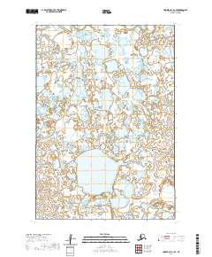
2020 Map of Hooper Bay C-1 SE
USGS Topo · Published 2020About this map
Chelunginik River meanders across this vast wetland expanse in the Kusilvak Census Area, showcasing the complex hydrologic network of the Yukon-Kuskokwim Delta. The landscape is defined by an intricate pattern of tundra ponds and small lakes that dominate the terrain between the primary watercourses. To the south, the Noriyauck River flows through a region where the land and water are nearly inseparable, a characteristic common in this part of western Alaska. This 2020 survey provides a modern record of these shifting waterways and the precise public land survey system grid lines that organize this largely roadless wilderness. The absence of human-built infrastructure highlights the area's role as a natural habitat, where the drainage patterns of the Chelunginik River dictate the geography of the surrounding basins.
Find a feature on this map
8 named features on this map. Tap any name to fly to it.
Don’t see what you’re looking for? This feature index may not catch every label — zoom into the map to look around manually.
Map Details
Editions of this 2020 Hooper Bay C-1 SE Map
This is the sole edition of this map. No revisions or reprints were ever made.
Other maps of this area

1951 · Marshall
USGS Topo · 1:250,000

1951 · Hooper Bay
USGS Topo · 1:250,000
1952 · Marshall C-8
USGS Topo · 1:63,360
1952 · Hooper Bay C-1
USGS Topo · 1:63,360

1953 · Hooper Bay
USGS Topo · 1:250,000
1953 · Hooper Bay B-1
USGS Topo · 1:63,360
1953 · Marshall B-8
USGS Topo · 1:63,360

1954 · Marshall
USGS Topo · 1:250,000

1964 · Hooper Bay
USGS Topo · 1:250,000
2020 · Marshall C-8 SW
USGS Topo · 1:25,000