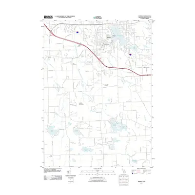
2011 Map of Howell
USGS Topo · Published 2011About this map
Howell serves as a central hub for Livingston County, characterized by a dense grid of residential streets and a concentration of civic landmarks. The town is flanked by significant water bodies, including Thompson Lake to the north and Earl Lake to the east, while the South Branch Shiawassee River and Red Cedar River drain the surrounding countryside. This landscape is notably dense with commemorative sites, ranging from the central Mount Olivet Cemetery and Lakeview Cemetery to more remote family and institutional burial grounds like the Livingston County Poor Farm Cemetery and Drew Cemetery. These sites provide a direct link to the region's 19th and 20th-century social history. Higher education and local services are represented by Cleary University and the Howell Post Office, reflecting the town's role as a regional anchor. The southern portion of the area transitions into a more hydrologically complex terrain, featuring numerous smaller lakes such as Coon Lake, Pardee Lake, and Cranberry Lake.
Find a feature on this map
139 named features on this map. Tap any name to fly to it.
Don’t see what you’re looking for? This feature index may not catch every label — zoom into the map to look around manually.
Map Details
Editions of this 2011 Howell Map
This is the sole edition of this map. No revisions or reprints were ever made.
Other maps of this area

1902 · Dexter
USGS Topo · 1:62,500

1904 · Ann Arbor
USGS Topo · 1:125,000

1906 · Dexter
USGS Topo · 1:62,500

1907 · Howell
USGS Topo · 1:62,500

1908 · Ann Arbor
USGS Topo · 1:125,000

1908 · Fowlerville
USGS Topo · 1:62,500

1909 · Howell
USGS Topo · 1:62,500

1910 · Fowlerville
USGS Topo · 1:62,500

1919 · Stockbridge
USGS Topo · 1:62,500

1922 · Stockbridge
USGS Topo · 1:62,500