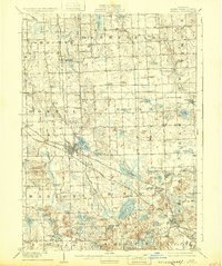
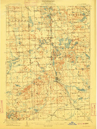
1909 Map of Howell
USGS Topo · Published 1932About this map
Howell and Brighton anchor this early twentieth-century survey of Livingston County, Michigan, showing a landscape defined by its glacial lakes and developing transportation corridors. The region is a dense network of country schoolhouses like the Marr School and Bitten School, alongside civic landmarks such as the State Sanitarium and various local Town Halls. The Shiawassee River winds through the northern townships of Cohoctah and Deerfield, while the southern reaches are dotted with named bodies of water including Lake Chemung, Thompson Lake, and Triangle Lake. The map details the vital rail infrastructure of the era, specifically the Ann Arbor Railroad and the Pere Marquette Railroad, which facilitated the growth of smaller settlements such as Chilson and Oak Grove.
Find a feature on this map
89 named features on this map. Tap any name to fly to it.
Don’t see what you’re looking for? This feature index may not catch every label — zoom into the map to look around manually.
Map Details
Editions of this 1909 Howell Map
2 editions found
Other maps of this area

1902 · South Lyon
USGS Topo · 1:62,500

1902 · Dexter
USGS Topo · 1:62,500

1904 · Ann Arbor
USGS Topo · 1:125,000

1906 · Dexter
USGS Topo · 1:62,500

1906 · South Lyon
USGS Topo · 1:62,500

1907 · Howell
USGS Topo · 1:62,500

1908 · Ann Arbor
USGS Topo · 1:125,000

1908 · Fowlerville
USGS Topo · 1:62,500

1909 · Howell
USGS Topo · 1:62,500
1909 · Milford
USGS Topo · 1:62,500
Featured Places
- Hamburg Township, MI
- Genoa Charter Township, MI
- Green Oak Charter Township, MI
- Brighton Charter Township, MI
- Hartland Township, MI