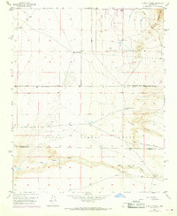
1952 Map of Hubbell Spring
USGS Topo · Published 1969About this map
Mc Cormick Ranch and the small settlement of Coyote occupy the high desert floor south of Albuquerque, situated where the terrain begins its ascent toward the Manzano Mts. The landscape is defined by its arid drainage systems, notably Hells Canyon Wash and Cañada Colorada, which cut through the southern portion of the sheet. This area marks a significant junction of land jurisdictions, with the Sandia Military Reservation bordering the northern expanse and the Isleta Pueblo Grant covering the central and southern reaches.
Find a feature on this map
22 named features on this map. Tap any name to fly to it.
Don’t see what you’re looking for? This feature index may not catch every label — zoom into the map to look around manually.
Map Details
Editions of this 1952 Hubbell Spring Map
4 editions found
Other maps of this area

1888 · Bernalillo
USGS Topo · 1:125,000

1889 · Albuquerque
USGS Topo · 1:125,000

1892 · San Pedro
USGS Topo · 1:125,000

1893 · Albuquerque
USGS Topo · 1:125,000

1917 · Estancia
USGS Topo · 1:125,000

1934 · West Albuquerque
USGS Topo · 1:24,000

1934 · East Albuquerque
USGS Topo · 1:24,000

1938 · Albuquerque
USGS Topo · 1:62,500

1952 · Hubbell Spring
USGS Topo · 1:24,000

1952 · Los Lunas SE
USGS Topo · 1:24,000