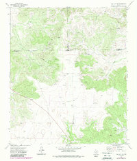
1972 Map of Hulldale SW
USGS Topo · Published 1988About this map
The West Texas plateau in the early 1970s is defined here by the confluence of Irion, Tom Green, and Schleicher counties. This arid landscape is shaped by the extraction of natural resources, with numerous Oil Wells, Gas Wells, and Gravel Pits peppered throughout the draws and ridges. A prominent Pipeline cuts diagonally across the terrain, serving the energy infrastructure anchored by a Pumping Sta in the central basin.
Find a feature on this map
16 named features on this map. Tap any name to fly to it.
Don’t see what you’re looking for? This feature index may not catch every label — zoom into the map to look around manually.
Map Details
Editions of this 1972 Hulldale SW Map
2 editions found
Other maps of this area

1895 · Sherwood
USGS Topo · 1:125,000

1954 · Sonora
USGS Topo · 1:250,000

1954 · San Angelo
USGS Topo · 1:250,000

1958 · Sonora
USGS Topo · 1:250,000

1958 · San Angelo
USGS Topo · 1:250,000

1964 · Eldorado NW
USGS Topo · 1:24,000
1964 · Eldorado NE
USGS Topo · 1:24,000

1964 · Moore Ranch
USGS Topo · 1:24,000

1965 · San Angelo
USGS Topo · 1:250,000
1972 · Hulldale NW
USGS Topo · 1:24,000