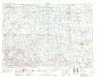
1953 Map of Huron
USGS Topo · Published 1959About this map
The Missouri River and James River valley systems define this mid-century survey of the South Dakota prairie, framing a landscape shaped by hydrology and steam-era rail lines. The Huron city center serves as a major hub for the Chicago and North Western and the Chicago Milwaukee St Paul and Pacific railroads, which connect dozens of agricultural outposts like Wessington, Wolsey, and Doland. To the southwest, the Crow Creek Indian Reservation and Lower Brule Indian Reservation flank the winding Missouri, showing the layout of Fort Thompson and Lower Brule before significant shoreline changes. Countless prairie potholes and small basins, such as Lake Louise and Cottonwood Lake, dot the landscape between the larger settlements of Redfield and Wessington Springs, illustrating the intricate drainage patterns of Beadle County and its neighbors.
Find a feature on this map
82 named features on this map. Tap any name to fly to it.
Don’t see what you’re looking for? This feature index may not catch every label — zoom into the map to look around manually.
Map Details
Editions of this 1953 Huron Map
3 editions found

Other maps of this area

1894 · Conde
USGS Topo · 1:62,500

1895 · Byron
USGS Topo · 1:125,000

1895 · Aberdeen
USGS Topo · 1:125,000

1898 · Huron
USGS Topo · 1:125,000

1899 · Mitchell
USGS Topo · 1:125,000

1899 · Northville
USGS Topo · 1:125,000

1899 · Alexandria
USGS Topo · 1:125,000

1899 · Redfield
USGS Topo · 1:125,000

1899 · De Smet
USGS Topo · 1:125,000

1934 · Canning
USGS Topo · 1:48,000