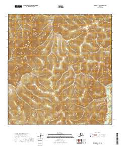
2019 Map of Iditarod A-5 SW
USGS Topo · Published 2019About this map
DeCourcy Mtn and the Kuskokwim Mountains define the high ground of this interior landscape on the border of the Yukon-Koyukuk and Bethel Census Areas. A dense network of drainage systems, including Smith Cr, Grouse Cr, and the winding Crooked Cr, carves through the terrain, suggesting the complex hydrology of the Alaskan bush. The presence of Omega Gulch near the southeastern corner indicates a rugged local topography where seasonal runoff has shaped the land over millennia. This 2019 survey, based on imagery from the previous decade, provides a technical view of a largely uninhabited wilderness where land management boundaries like t24n r50w and t23n r49w are the primary human imprints on an otherwise untamed environment.
Find a feature on this map
15 named features on this map. Tap any name to fly to it.
Don’t see what you’re looking for? This feature index may not catch every label — zoom into the map to look around manually.
Map Details
Editions of this 2019 Iditarod A-5 SW Map
This is the sole edition of this map. No revisions or reprints were ever made.
Other maps of this area

1950 · Sleetmute
USGS Topo · 1:250,000

1951 · Iditarod
USGS Topo · 1:250,000

1954 · Sleetmute D-6
USGS Topo · 1:63,360
1954 · Sleetmute D-7
USGS Topo · 1:63,360

1954 · Iditarod A-6
USGS Topo · 1:63,360

1954 · Iditarod A-5
USGS Topo · 1:63,360

1954 · Sleetmute
USGS Topo · 1:250,000

1956 · Iditarod
USGS Topo · 1:250,000
2019 · Sleetmute D-7 NE
USGS Topo · 1:25,000
2019 · Sleetmute D-7 NW
USGS Topo · 1:25,000