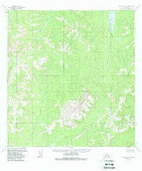
1954 Map of Iditarod B-2
USGS Topo · Published 1988About this map
Granite Mountain dominates this interior Alaska landscape, rising above a complex network of drainages that feed the Kuskokwim River watershed. Surveyed in the mid-1950s, the terrain shows no roads or trails, illustrating the remote character of the Iditarod region during this era. The hydrological pattern is defined by the Big Waldren Fork and Little Waldren Fork, which meander through the northern half of the quadrangle. To the south, the headwaters of the East Fork George River take shape, supported by tributaries such as Moose Creek and Munther Creek. Small water bodies like Homestake Ct and Granite Creek are etched into the higher elevations, while the Little East Fork drains the eastern slopes of the central massif. This map provides a detailed view of the raw topography and drainage systems prior to modern developments or significant human footprint in the area.
Find a feature on this map
9 named features on this map. Tap any name to fly to it.
Don’t see what you’re looking for? This feature index may not catch every label — zoom into the map to look around manually.
Map Details
Editions of this 1954 Iditarod B-2 Map
3 editions found
Other maps of this area

1951 · Iditarod
USGS Topo · 1:250,000

1954 · Iditarod B-1
USGS Topo · 1:63,360

1954 · Iditarod A-1
USGS Topo · 1:63,360

1954 · Iditarod B-2
USGS Topo · 1:63,360

1954 · Iditarod A-3
USGS Topo · 1:63,360

1954 · Iditarod A-2
USGS Topo · 1:63,360

1954 · Iditarod C-3
USGS Topo · 1:63,360

1954 · Iditarod B-3
USGS Topo · 1:63,360

1954 · Iditarod C-2
USGS Topo · 1:63,360
1956 · Iditarod C-1
USGS Topo · 1:63,360