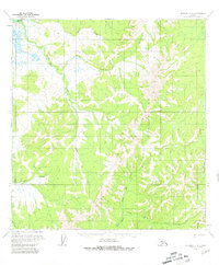
1954 Map of Iditarod C-4
USGS Topo · Published 1981About this map
The Iditarod River meanders through the northwest corner of this Interior Alaska landscape, part of a complex hydrologic network that includes the Dishna River and Otter Creek. Based on 1953 and 1954 aerial photography, the terrain is defined by prominent elevations such as Hickey Mtn and Caribou Mtn, which overlook a series of drainages including Twin Island Creek and Hickey Creek.
Find a feature on this map
13 named features on this map. Tap any name to fly to it.
Don’t see what you’re looking for? This feature index may not catch every label — zoom into the map to look around manually.
Map Details
Editions of this 1954 Iditarod C-4 Map
2 editions found
Other maps of this area

1951 · Iditarod
USGS Topo · 1:250,000

1954 · Iditarod C-4
USGS Topo · 1:63,360

1954 · Iditarod B-5
USGS Topo · 1:63,360

1954 · Iditarod C-5
USGS Topo · 1:63,360

1954 · Iditarod C-3
USGS Topo · 1:63,360

1954 · Iditarod B-3
USGS Topo · 1:63,360

1954 · Iditarod D-5
USGS Topo · 1:63,360

1954 · Iditarod B-4
USGS Topo · 1:63,360

1954 · Iditarod D-3
USGS Topo · 1:63,360

1954 · Iditarod D-4
USGS Topo · 1:63,360