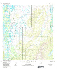
1954 Map of Iditarod D-4
USGS Topo · Published 1984About this map
Iditarod River meanders through the western half of this interior Alaskan landscape, defining a complex network of wetlands and sloughs within what is now the Innoko National Wildlife Refuge. Based on 1950s data, the map identifies the Dikeman (Site) on the riverbank, alongside smaller outposts like Windy and a solitary Cabin near the Dishna River. The topography transitions from these low-lying river basins to higher ground in the Innoko Wilderness to the east. Several transportation routes are documented, including a Tractor Trail and the Hunter Trail, which navigate the interior between tributaries such as Horsefly Creek, Glacier Creek, and First Chance Creek. This 1954 data records a specific era of wilderness management and localized settlement before the formal establishment of the modern refuge boundaries.
Find a feature on this map
16 named features on this map. Tap any name to fly to it.
Don’t see what you’re looking for? This feature index may not catch every label — zoom into the map to look around manually.
Map Details
Editions of this 1954 Iditarod D-4 Map
2 editions found

Other maps of this area

1951 · Ophir
USGS Topo · 1:250,000

1951 · Iditarod
USGS Topo · 1:250,000

1954 · Iditarod C-4
USGS Topo · 1:63,360

1954 · Ophir A-5
USGS Topo · 1:63,360

1954 · Iditarod C-5
USGS Topo · 1:63,360

1954 · Iditarod C-3
USGS Topo · 1:63,360

1954 · Iditarod D-5
USGS Topo · 1:63,360

1954 · Ophir A-3
USGS Topo · 1:63,360

1954 · Ophir A-4
USGS Topo · 1:63,360

1954 · Iditarod D-3
USGS Topo · 1:63,360