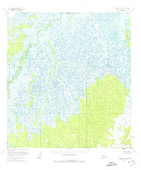
1954 Map of Iditarod D-5
USGS Topo · Published 1975About this map
The Iditarod River meanders across this interior Alaskan landscape, characterized by complex river systems and expansive wetland terrain as it was recorded in the mid-1950s. The map illustrates the highly sinuous nature of the Yetna River, which flows through the western portion of the quadrangle. These waterways define the drainage patterns of a region where land lines remained largely unsurveyed, as noted by the North Boundary Seward Meridian. The topography consists primarily of low-lying swampy areas and numerous small lakes, indicating a remote wilderness environment typical of the Yukon-Koyukuk region before significant modern development. The absence of roads or established settlements on this sheet highlights the isolation and reliance on river corridors for navigation and exploration during this era.
Find a feature on this map
3 named features on this map. Tap any name to fly to it.
Don’t see what you’re looking for? This feature index may not catch every label — zoom into the map to look around manually.
Map Details
Editions of this 1954 Iditarod D-5 Map
3 editions found
Other maps of this area

1951 · Ophir
USGS Topo · 1:250,000

1951 · Iditarod
USGS Topo · 1:250,000

1954 · Ophir A-6
USGS Topo · 1:63,360

1954 · Iditarod D-6
USGS Topo · 1:63,360

1954 · Iditarod C-4
USGS Topo · 1:63,360

1954 · Ophir A-5
USGS Topo · 1:63,360

1954 · Iditarod C-5
USGS Topo · 1:63,360
1954 · Iditarod C-6
USGS Topo · 1:63,360

1954 · Iditarod D-5
USGS Topo · 1:63,360

1954 · Ophir A-4
USGS Topo · 1:63,360