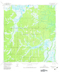
1954 Map of Iditarod D-6
USGS Topo · Published 1983About this map
The Netletna River flows through this interior Alaskan wilderness, as documented by photogrammetric methods in the mid-1950s. The landscape is defined by the meandering courses of the Big Yetna River and Little Yetna River, creating a complex network of wetlands and seasonal waterways typical of the Yukon-Koyukuk region. This 1954 survey captures the terrain long before modern federal land designations were finalized, though this edition later includes the boundaries for the Innoko National Wildlife Refuge and the Innoko Wilderness. The lack of named settlements or man-made structures emphasizes the untouched nature of this remote river system, where the North Boundary Seward Meridian serves as one of the few formal geographic reference points in a region dominated by hydrological features.
Find a feature on this map
7 named features on this map. Tap any name to fly to it.
Don’t see what you’re looking for? This feature index may not catch every label — zoom into the map to look around manually.
Map Details
Editions of this 1954 Iditarod D-6 Map
3 editions found

Other maps of this area

1951 · Ophir
USGS Topo · 1:250,000

1951 · Unalakleet
USGS Topo · 1:250,000

1951 · Holy Cross
USGS Topo · 1:250,000

1951 · Iditarod
USGS Topo · 1:250,000

1952 · Unalakleet A-1
USGS Topo · 1:63,360

1952 · Holy Cross C-1
USGS Topo · 1:63,360

1952 · Holy Cross D-1
USGS Topo · 1:63,360

1952 · Unalakleet
USGS Topo · 1:250,000

1952 · Holy Cross
USGS Topo · 1:250,000

1954 · Ophir A-6
USGS Topo · 1:63,360