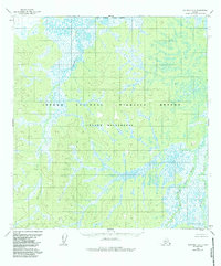
1954 Map of Iditarod D-6
USGS Topo · Published 1983About this map
The Netletna River serpentines through a complex hydrological landscape in this mid-century survey of the Alaska interior. The area is dominated by the extensive wetlands of the Innoko National Wildlife Refuge, where the terrain is characterized by intricate drainage patterns and low-relief marshlands. Within the refuge lies the Innoko Wilderness, a protected expanse that preserves the natural state of this subarctic ecosystem. The confluence and divergence of the Big Yetna River and Little Yetna River in the eastern portion of the map reveal a shifting river-and-wetland network that remains largely untouched by permanent settlement or infrastructure. This topography, compiled from aerial photography taken in 1953, serves as a record of the remote wilderness before the establishment of modern conservation boundaries and minor 1980s revisions.
Find a feature on this map
7 named features on this map. Tap any name to fly to it.
Don’t see what you’re looking for? This feature index may not catch every label — zoom into the map to look around manually.
Map Details
Editions of this 1954 Iditarod D-6 Map
3 editions found

Other maps of this area

1951 · Ophir
USGS Topo · 1:250,000

1951 · Unalakleet
USGS Topo · 1:250,000

1951 · Holy Cross
USGS Topo · 1:250,000

1951 · Iditarod
USGS Topo · 1:250,000

1952 · Unalakleet A-1
USGS Topo · 1:63,360

1952 · Holy Cross C-1
USGS Topo · 1:63,360

1952 · Holy Cross D-1
USGS Topo · 1:63,360

1952 · Unalakleet
USGS Topo · 1:250,000

1952 · Holy Cross
USGS Topo · 1:250,000

1954 · Ophir A-6
USGS Topo · 1:63,360