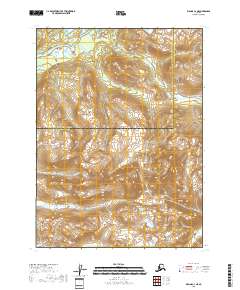
2018 Map of Iliamna C-3 NE
USGS Topo · Published 2018About this map
The Iliamna River winds through the northern reaches of this landscape, a vital waterway at the edge of the Kenai Peninsula Borough and Lake and Peninsula Borough boundary. The Williamsport-Pile Bay Road provides the primary overland corridor through the interior, connecting remote drainages. This terrain is defined by its complex hydrology, with the high-elevation headwaters of Chinkelyes Cr, Silver Cr, and Ptarmigan Cr carving through the steep topography. The map illustrates a transitional zone where human infrastructure is limited to a single strategic roadway, leaving the vast majority of the river systems in their natural state. These features highlight the importance of the narrow transportation route in navigating the difficult geography of this region.
Find a feature on this map
10 named features on this map. Tap any name to fly to it.
Don’t see what you’re looking for? This feature index may not catch every label — zoom into the map to look around manually.
Map Details
Editions of this 2018 Iliamna C-3 NE Map
This is the sole edition of this map. No revisions or reprints were ever made.
Other maps of this area

1952 · Iliamna
USGS Topo · 1:250,000

1954 · Iliamna D-3
USGS Topo · 1:63,360

1954 · Iliamna C-3
USGS Topo · 1:63,360

1957 · Iliamna
USGS Topo · 1:250,000

1958 · Iliamna D-2
USGS Topo · 1:63,360

1958 · Iliamna C-2
USGS Topo · 1:63,360
2018 · Iliamna D-3 SE
USGS Topo · 1:25,000
2018 · Iliamna C-3 NW
USGS Topo · 1:25,000
2018 · Iliamna C-3 SE
USGS Topo · 1:25,000

2018 · Iliamna D-2 SW
USGS Topo · 1:25,000