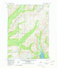
1958 Map of Iliamna D-2
USGS Topo · Published 1981About this map
The Chigmit Mountains dominate this region of the Kenai Peninsula Borough, where steep peaks and glacial systems define the drainage patterns of the Alaskan wilderness. Based on 1957 aerial photography and 1958 field annotations, the map shows the transition from high-altitude features like Roscoe Glacier and Roscoe Peak down to the tidal flats of Iniskin Bay. Significant river systems, including the Pile River, Iliamna River, and Iniskin River, carve deep valleys through the range, while Three Sisters Mountain serves as a prominent landmark in the western interior. Near the coast, the topography softens into the sediment-rich areas of Mud and Sugarloaf Mountain, reflecting the dynamic environment where mountain runoff meets the sea.
Find a feature on this map
12 named features on this map. Tap any name to fly to it.
Don’t see what you’re looking for? This feature index may not catch every label — zoom into the map to look around manually.
Map Details
Editions of this 1958 Iliamna D-2 Map
3 editions found
Other maps of this area

1946 · Lake Clark
USGS Topo · 1:250,000

1949 · Iliamna C-1
USGS Topo · 1:63,360

1951 · Lake Clark
USGS Topo · 1:250,000

1952 · Iliamna
USGS Topo · 1:250,000

1954 · Lake Clark A-3
USGS Topo · 1:63,360

1954 · Iliamna D-3
USGS Topo · 1:63,360

1954 · Iliamna C-3
USGS Topo · 1:63,360

1957 · Iliamna
USGS Topo · 1:250,000

1958 · Iliamna D-2
USGS Topo · 1:63,360

1958 · Iliamna C-2
USGS Topo · 1:63,360