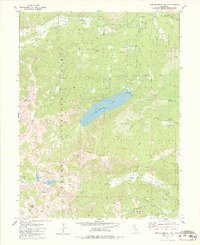
1981 Map of Independence Lake
USGS Topo · Published 1981About this map
Independence Lake serves as the central focal point of this high-elevation landscape within the Tahoe National Forest. The map documents a complex network of alpine meadows and high ridges, including Perazzo Meadows, Carpenter Valley, and the prominent Mt Lola. The drainage patterns are clearly defined, showing how Independence Creek and the North Fork Prosser Creek navigate the terrain of Carpenter Ridge and the Sagehen Hills.
Find a feature on this map
37 named features on this map. Tap any name to fly to it.
Don’t see what you’re looking for? This feature index may not catch every label — zoom into the map to look around manually.
Map Details
Editions of this 1981 Independence Lake Map
3 editions found
Other maps of this area

1890 · Sierraville
USGS Topo · 1:125,000

1891 · Truckee
USGS Topo · 1:125,000

1892 · Sierraville
USGS Topo · 1:125,000

1893 · Truckee
USGS Topo · 1:125,000

1894 · Sierraville
USGS Topo · 1:125,000

1895 · Truckee
USGS Topo · 1:125,000

1932 · Truckee
USGS Topo · 1:96,000

1940 · Truckee
USGS Topo · 1:125,000

1955 · Truckee
USGS Topo · 1:24,000

1955 · Loyalton
USGS Topo · 1:62,500