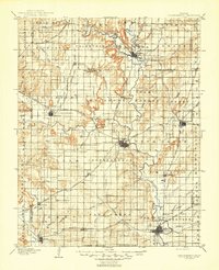
1905 Map of Independence
USGS Topo · Published 1945About this map
Independence serves as the central hub of this turn-of-the-century landscape, where the Verdigris River and Fall River meet a complex web of early railroads. The map documents a period of significant growth for Coffeyville and Neodesha, defined by the industrial reach of the Atchison Topeka and Santa Fe RR and the Missouri Pacific RR. Beyond the larger towns, the rural character of Southeast Kansas is evident in the many small railroad stops and settlements like Lafontaine, Havana, and Tyro. Distinctive geological features such as Table Mound, Buff Mound, and Walker Mound rise above the river valleys, providing prominent landmarks for early travelers and surveyors. This map captures the agricultural and transportation networks of Montgomery and Wilson counties just years after the frontier era, highlighting the density of small township boundaries and the intricate drainage patterns of creeks like Onion Creek and Duck Creek.
Find a feature on this map
93 named features on this map. Tap any name to fly to it.
Don’t see what you’re looking for? This feature index may not catch every label — zoom into the map to look around manually.
Map Details
Editions of this 1905 Independence Map
4 editions found

Other maps of this area

1885 · Eureka
USGS Topo · 1:125,000

1885 · Sedan
USGS Topo · 1:125,000

1886 · Fredonia
USGS Topo · 1:125,000

1886 · Iola
USGS Topo · 1:125,000

1886 · Independence
USGS Topo · 1:125,000

1886 · Parsons
USGS Topo · 1:125,000

1888 · Eureka
USGS Topo · 1:125,000

1889 · Sedan
USGS Topo · 1:125,000

1893 · Iola
USGS Topo · 1:125,000

1893 · Parsons
USGS Topo · 1:125,000