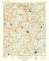
1905 Map of Independence
USGS Topo · Published 1949About this map
The Verdigris River and Elk River define the agricultural and industrial landscape of Southeast Kansas in this 1903 survey. The rail infrastructure of the early twentieth century is meticulously documented, showing the convergence of the St. Louis and San Francisco RR, the Atchison Topeka and Santa Fe RR, and the Missouri Pacific RR. These lines linked growing hubs like Independence, Coffeyville, and Cherryvale to the broader regional economy. Significant geological landmarks such as Table Mound, Buff Mound, and Walker Mound rise above the drainage basins, while smaller settlements including Lafontaine, Havana, and Tyro appear at regular intervals along the rail corridors. Near the southern border, the Kansas Oklahoma Boundary Line marks the transition into what was then Indian Territory, just years before Oklahoma statehood.
Find a feature on this map
86 named features on this map. Tap any name to fly to it.
Don’t see what you’re looking for? This feature index may not catch every label — zoom into the map to look around manually.
Map Details
Editions of this 1905 Independence Map
4 editions found

Other maps of this area

1885 · Eureka
USGS Topo · 1:125,000

1885 · Sedan
USGS Topo · 1:125,000

1886 · Fredonia
USGS Topo · 1:125,000

1886 · Iola
USGS Topo · 1:125,000

1886 · Independence
USGS Topo · 1:125,000

1886 · Parsons
USGS Topo · 1:125,000

1888 · Eureka
USGS Topo · 1:125,000

1889 · Sedan
USGS Topo · 1:125,000

1893 · Iola
USGS Topo · 1:125,000

1893 · Parsons
USGS Topo · 1:125,000