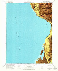
1968 Map of Indian Cove
USGS Topo · Published 1972About this map
Great Salt Lake dominates this orthophotomap, which utilizes aerial imagery from the late 1960s to document the fluctuating shoreline of Indian Cove. The map records a specific hydrological moment, noting an elevation of 4193 feet in late 1966. Along the eastern edge, the topography rises sharply away from the Mud Flat into the Promontory Mountains, where drainage features like Miller Canyon and landmarks such as the Indian Caves are clearly visible. The southern portion of the sheet reveals the Ship Channel, a critical navigational feature for the industrial and recreational use of the lake. This transition from open water to shoreline is marked only by a few miles of unimproved dirt roads, highlighting the isolation of this stretch of Box Elder County during the period.
Find a feature on this map
10 named features on this map. Tap any name to fly to it.
Don’t see what you’re looking for? This feature index may not catch every label — zoom into the map to look around manually.
Map Details
Editions of this 1968 Indian Cove Map
3 editions found
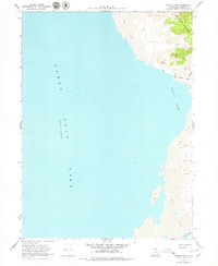
Other maps of this area

1954 · Brigham City
USGS Topo · 1:250,000

1958 · Brigham City
USGS Topo · 1:250,000

1962 · Brigham City
USGS Topo · 1:250,000

1967 · East Promontory
USGS Topo · 1:24,000

1968 · Messix Peak
USGS Topo · 1:24,000

1968 · Indian Cove
USGS Topo · 1:24,000

1968 · Pokes Point
USGS Topo · 1:24,000

1968 · Rozel Point
USGS Topo · 1:24,000

1968 · Promontory Point
USGS Topo · 1:24,000

1969 · Rozel Point SW
USGS Topo · 1:24,000