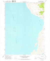
1968 Map of Indian Cove
USGS Topo · Published 1979About this map
Great Salt Lake dominates this shoreline survey, reflecting its level at a specific moment in late 1966. Along the eastern edge, the Promontory Mountains rise sharply above the water, creating a stark interface between high terrain and expansive Mud Flats. The map documents a landscape defined by the shifting margin of the lake, where inland drainage through Miller Canyon meets the saltwater basin at Indian Cove.
Find a feature on this map
12 named features on this map. Tap any name to fly to it.
Don’t see what you’re looking for? This feature index may not catch every label — zoom into the map to look around manually.
Map Details
Editions of this 1968 Indian Cove Map
3 editions found
Other maps of this area

1954 · Brigham City
USGS Topo · 1:250,000

1958 · Brigham City
USGS Topo · 1:250,000

1962 · Brigham City
USGS Topo · 1:250,000

1967 · East Promontory
USGS Topo · 1:24,000

1968 · Messix Peak
USGS Topo · 1:24,000

1968 · Indian Cove
USGS Topo · 1:24,000

1968 · Pokes Point
USGS Topo · 1:24,000

1968 · Rozel Point
USGS Topo · 1:24,000

1968 · Promontory Point
USGS Topo · 1:24,000

1969 · Rozel Point SW
USGS Topo · 1:24,000