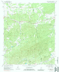
1967 Map of Indian Mountain
USGS Topo · Published 1987About this map
Indian Mountain dominates the center of this landscape along the Alabama-Georgia border, marking a rugged terrain punctuated by small agricultural and mining communities in the late 1960s. The southern portion of the map reveals a heavy industrial and transit corridor where the Southern railroad connects Bluffton, Etna, and Prior. Local heritage is anchored by numerous rural assembly points, including Nazareth Ch, Hopewell Ch, and Bethel Ch, alongside small crossroads such as McCord Crossroads and Adams Crossroads. Distinctive topographical features like Flagpole Mtn and Shorty Mtn rise above the drainage of Spring Creek and Lumpkin Mill Creek. The presence of a Claypit near Wolfden Mtn and a Gravel Pit near Rocky Hollow indicates the area's continued reliance on local extractive resources during this era.
Find a feature on this map
65 named features on this map. Tap any name to fly to it.
Don’t see what you’re looking for? This feature index may not catch every label — zoom into the map to look around manually.
Map Details
Editions of this 1967 Indian Mountain Map
3 editions found
Other maps of this area

1886 · Rome
USGS Topo · 1:125,000

1889 · Tallapoosa
USGS Topo · 1:125,000

1892 · Tallapoosa
USGS Topo · 1:125,000

1893 · Fort Payne
USGS Topo · 1:125,000

1897 · Tallapoosa
USGS Topo · 1:125,000

1898 · Rome
USGS Topo · 1:125,000

1898 · Fort Payne
USGS Topo · 1:125,000

1899 · Rome
USGS Topo · 1:125,000

1900 · Fort Payne
USGS Topo · 1:125,000

1900 · Anniston
USGS Topo · 1:125,000