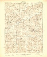
1931 Map of Indianola
USGS Topo · Published 1931About this map
Indianola serves as the focal point of this Warren County landscape, situated at the intersection of State Highway No 2 and State Highway No 65. The 1928 survey captures a complex network of steam railroads, including the Chicago Rock Island and Pacific RR and the Chicago Great Western RR, which connect scattered agricultural communities such as Martensdale, Spring Hill, and Summerset. The terrain is defined by the winding paths of the Middle River, North River, and South River, which created the fertile valleys that supported the area's early 20th-century development.
Find a feature on this map
73 named features on this map. Tap any name to fly to it.
Don’t see what you’re looking for? This feature index may not catch every label — zoom into the map to look around manually.
Map Details
Editions of this 1931 Indianola Map
4 editions found
Other maps of this area

1905 · Des Moines
USGS Topo · 1:62,500

1907 · Des Moines
USGS Topo · 1:62,500

1908 · Waukee
USGS Topo · 1:62,500

1910 · Milo
USGS Topo · 1:62,500

1918 · Chariton
USGS Topo · 1:62,500

1930 · Mitchellville
USGS Topo · 1:62,500

1931 · Indianola
USGS Topo · 1:62,500

1950 · New Virginia
USGS Topo · 1:62,500

1951 · Osceola
USGS Topo · 1:62,500

1951 · St. Charles
USGS Topo · 1:62,500