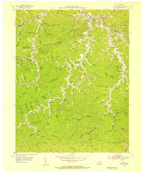
1954 Map of Inez
USGS Topo · Published 1955About this map
The town of Inez serves as the focal point for this mid-century survey of Martin County, Kentucky. This era of development is defined by a dense network of mountain hollows and the early expansion of the regional energy economy, evidenced by numerous Gas Wells and Oil Wells scattered across the landscape. The social structure of these remote valleys is clearly mapped through its rural institutions, with schools like Sandlick Sch, Beech Fork Sch, and Lynn Bark Sch positioned along the creek forks that dictated local movement. Smaller settlements like Davella and Debord anchor the intersections of waterways such as Middle Fork and Bark Fork. The presence of several family-named landmarks and the Ward Cem provide essential data for those researching the deep genealogy of this Appalachian coalfield region before modern mining and infrastructure altered the traditional terrain.
Find a feature on this map
80 named features on this map. Tap any name to fly to it.
Don’t see what you’re looking for? This feature index may not catch every label — zoom into the map to look around manually.
Map Details
Editions of this 1954 Inez Map
3 editions found
Other maps of this area

1886 · Prestonsburg
USGS Topo · 1:125,000

1887 · Warfield
USGS Topo · 1:125,000

1891 · Warfield
USGS Topo · 1:125,000

1892 · Prestonsburg
USGS Topo · 1:125,000

1910 · Naugatuck
USGS Topo · 1:48,000

1912 · Naugatuck
USGS Topo · 1:62,500

1914 · Laynesville
USGS Topo · 1:48,000

1914 · Inez
USGS Topo · 1:48,000

1915 · Williamson
USGS Topo · 1:48,000

1915 · Naugatuck
USGS Topo · 1:48,000