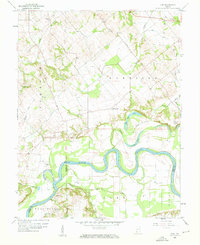
1958 Map of Iona
USGS Topo · Published 1960About this map
The White River carves a deep, winding path through this Knox County landscape, defining the boundaries and agricultural patterns of the late 1950s. The river's serpentine course is echoed by numerous oxbows and water bodies like Long Pond, which suggests a flood-prone bottomland historically managed for farming. Smaller settlements such as Iona and Ridgeville serve as local hubs, connected by a network of rural thoroughfares including Main Street, Williams Road, and Hart Street.
Find a feature on this map
14 named features on this map. Tap any name to fly to it.
Don’t see what you’re looking for? This feature index may not catch every label — zoom into the map to look around manually.
Map Details
Editions of this 1958 Iona Map
3 editions found
Other maps of this area

1901 · Princeton
USGS Topo · 1:62,500

1902 · Ditney
USGS Topo · 1:125,000

1903 · Petersburg
USGS Topo · 1:62,500

1903 · Princeton
USGS Topo · 1:62,500

1903 · Patoka
USGS Topo · 1:125,000

1915 · Vincennes
USGS Topo · 1:62,500

1942 · Fritchton
USGS Topo · 1:24,000

1944 · Fritchton
USGS Topo · 1:24,000

1944 · Monroe City
USGS Topo · 1:24,000

1944 · Wheatland
USGS Topo · 1:24,000