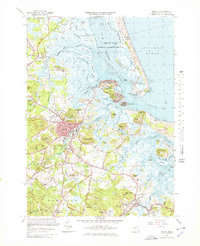
1966 Map of Ipswich
USGS Topo · Published 1978About this map
Ipswich River winds through the heart of this coastal landscape, passing the established town center of Ipswich before emptying into the vast marshlands and tidal flats of Ipswich Bay. The complex maritime geography is defined by the shifting sands of Plum Island and the protective arm of Castle Neck, creating a network of interior waterways including Plum Island Sound and Roger Island River. These waters separate numerous landforms such as Hog Island and Grape Island from the mainland, where the Boston and Maine railroad line connects the settlements of Rowley and Essex.
Find a feature on this map
155 named features on this map. Tap any name to fly to it.
Don’t see what you’re looking for? This feature index may not catch every label — zoom into the map to look around manually.
Map Details
Editions of this 1966 Ipswich Map
Other maps of this area

1886 · Gloucester
USGS Topo · 1:62,500

1888 · Newburyport
USGS Topo · 1:62,500

1888 · Gloucester
USGS Topo · 1:62,500

1888 · Salem
USGS Topo · 1:62,500

1890 · Newburyport
USGS Topo · 1:62,500

1893 · Salem
USGS Topo · 1:62,500

1893 · Gloucester
USGS Topo · 1:62,500

1894 · Newburyport
USGS Topo · 1:62,500

1917 · Salem
USGS Topo · 1:62,500

1918 · Gloucester
USGS Topo · 1:62,500