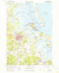
1966 Map of Ipswich
USGS Topo · Published 1976About this map
Plum Island Sound and the complex tidal estuaries of the Ipswich River define this coastal landscape on the North Shore. The 1966 revision shows the extensive protected lands of the Parker River National Wildlife Refuge and Plum Island State Park as they existed before significant modern shoreline shifts. Cultural and religious history is prominent here, marked by the Sisters of Notre Dame de Namur Novitiate and the Sacred Heart Juniorate, alongside the local healthcare landmark Cable Memorial Hosp. The map also illustrates the Cold War era presence of the Air Force Cambridge Research Laboratories situated near Eagle Hill. Coastal navigation is anchored by the Ipswich Light, while the inland area is connected by the Boston and Maine Railroad, which serves the historic town centers of Ipswich and Rowley.
Find a feature on this map
147 named features on this map. Tap any name to fly to it.
Don’t see what you’re looking for? This feature index may not catch every label — zoom into the map to look around manually.
Map Details
Editions of this 1966 Ipswich Map
Other maps of this area

1886 · Gloucester
USGS Topo · 1:62,500

1888 · Newburyport
USGS Topo · 1:62,500

1888 · Gloucester
USGS Topo · 1:62,500

1888 · Salem
USGS Topo · 1:62,500

1890 · Newburyport
USGS Topo · 1:62,500

1893 · Salem
USGS Topo · 1:62,500

1893 · Gloucester
USGS Topo · 1:62,500

1894 · Newburyport
USGS Topo · 1:62,500

1917 · Salem
USGS Topo · 1:62,500

1918 · Gloucester
USGS Topo · 1:62,500