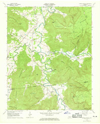
1960 Map of Irving College
USGS Topo · Published 1969About this map
Collins River carves a deep path through the Cumberland Plateau region of Warren and Grundy Counties, anchoring a landscape where narrow valleys meet prominent ridges like Brown Mountain and Nunley Mountain. The settlement of Irving College sits at a geographic crossroads, surrounded by smaller communities such as Safley and Center Hill. This 1960 field-checked survey reveals a rural society structured around local congregations and family landmarks, evidenced by numerous churches including St Marys Ch and Philadelphia Ch. High-elevation features like Pinnacle Point and Lookout Tower contrast with the low-lying agricultural pockets found in Myers Cove and Nunleys Cove. The presence of the Badger Mine and several gravel pits indicates the local extraction economy, while Camp Woodlee along the river highlights the area's role in early youth recreation and outdoor education.
Find a feature on this map
54 named features on this map. Tap any name to fly to it.
Don’t see what you’re looking for? This feature index may not catch every label — zoom into the map to look around manually.
Map Details
Editions of this 1960 Irving College Map
4 editions found
Other maps of this area

1893 · Mc Minnville
USGS Topo · 1:125,000

1895 · Mc Minnville
USGS Topo · 1:125,000

1895 · Sewanee
USGS Topo · 1:125,000

1936 · Cane Hollow
USGS Topo · 1:24,000

1943 · Mc Minnville
USGS Topo · 1:100,000

1953 · Chattanooga
USGS Topo · 1:250,000

1953 · Mc Minnville
USGS Topo · 1:24,000
1955 · Viola
USGS Topo · 1:24,000
1956 · Collins
USGS Topo · 1:24,000
1956 · Altamont
USGS Topo · 1:24,000