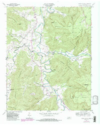
1960 Map of Irving College
USGS Topo · Published 1986About this map
Collins River meanders through a landscape defined by the rugged interface of the Highland Rim and the Cumberland Plateau, where the community of Irving College serves as a central anchor. This mid-century survey reveals a network of rural settlements and religious life, with numerous landmarks such as Hebron Ch, St Marys Ch, and Shiloh Ch dotting the valley floors. The complex topography is marked by significant elevations like Harrison Ferry Mountain and Brown Mountain, alongside geologic features like the Big Sink. Economic activity is evidenced by the Badger Mine and a Gravel Pit near Safley, while the local geography is further characterized by deep coves and hollows, including Savage Cove and Panther Cove. This map provides a detailed look at the Warren and Grundy County line during a period of transition, showing the distribution of homesteads and the enduring routes of the Harrison Ferry Trail.
Find a feature on this map
50 named features on this map. Tap any name to fly to it.
Don’t see what you’re looking for? This feature index may not catch every label — zoom into the map to look around manually.
Map Details
Editions of this 1960 Irving College Map
4 editions found
Other maps of this area

1893 · Mc Minnville
USGS Topo · 1:125,000

1895 · Mc Minnville
USGS Topo · 1:125,000

1895 · Sewanee
USGS Topo · 1:125,000

1936 · Cane Hollow
USGS Topo · 1:24,000

1943 · Mc Minnville
USGS Topo · 1:100,000

1953 · Chattanooga
USGS Topo · 1:250,000

1953 · Mc Minnville
USGS Topo · 1:24,000
1955 · Viola
USGS Topo · 1:24,000
1956 · Collins
USGS Topo · 1:24,000
1956 · Altamont
USGS Topo · 1:24,000